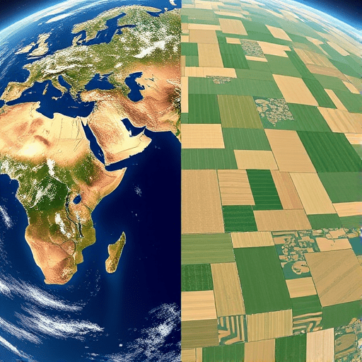
For agtech startups, choosing between Planet and Maxar satellite data is rarely a question of which provider is “better.” It’s a strategic decision that propagates through your entire product — from the AI models you can realistically train to the insights farmers actually act on. Planet provides daily global coverage at roughly three-meter resolution, enabling repeatable scans of every field on Earth. Maxar delivers sub-half-meter captures of specific areas, with lower revisit frequency and a higher price per square kilometer. Understanding this trade-off — daily global imagery against high-resolution captures — is central to building a defensible agtech product.
The market has matured in significant ways. Planet has expanded its constellation with Pelican and Tanager missions, pushing daily resolution below a meter and adding spectral bands for advanced vegetation analysis. Maxar’s WorldView Legion constellation has improved tasking capacity, reducing the time between request and delivery. The decision is no longer about technical feasibility; it’s about aligning data architecture with your startup’s go-to-market model.
Temporal vs. Spatial Resolution: Framing the Core Trade-Off
Every agtech startup begins with the same underlying question: what decisions are we enabling? Crop health monitoring, yield estimation, insurance verification, and irrigation management each demand different temporal and spatial inputs.
Temporal resolution determines how often you observe a field. Planet’s constellation revisits most of the globe daily, allowing startups to track vegetation indices like NDVI across the full growing season. That frequency makes it possible to detect stress events — drought onset, nitrogen deficiency, pest pressure — soon after they appear, and to feed time-series models with continuous, consistent data.
Spatial resolution, by contrast, determines what you can see within a single frame. Maxar’s 30-centimeter imagery can resolve individual plants, irrigation drip lines, soil compaction zones, and subtle symptoms of crop disease that are invisible at three meters. The real choice isn’t just about pixels; it’s about the granularity of insights your downstream models can deliver.
Daily Global Imagery for Agtech: Where Planet Excels
Planet’s strength is breadth. It captures the entire planet every day, creating a data asset that few startups could replicate on their own. For teams building continent-scale monitoring platforms, this is transformative. It powers anomaly detection across millions of hectares, supports the training of supervised machine learning models on millions of samples, and provides the historical context insurers and governments increasingly require.
The consistency and calibration of Planet’s data also matter for product development. Analytical-ready surface reflectance products, standardized metadata, and an archive spanning nearly a decade allow startups to establish historical baselines, calculate anomaly thresholds, and validate models against known past events before going to market. For an early-stage company, that historical depth is invaluable — you can test your science on previous growing seasons rather than waiting a full year for new captures to accumulate.
Planet is also a practical fit for platform architectures. Because imagery arrives on a fixed cadence and covers broad regions, it supports automated pipelines for mosaicking, time-series extraction, and analytics at scale. If your product is about monitoring trends across many fields and identifying outliers, Planet gives you the temporal foundation to build on.
High-Resolution Captures: When Maxar Is the Decisive Advantage
Maxar becomes the right choice when the problem requires spatial detail that no amount of temporal frequency can approximate. Consider several high-value agtech use cases:
- Early-stage disease detection: Certain fungal and viral diseases produce leaf-level symptoms that only become visible in sub-half-meter imagery days before they spread enough to appear in three-meter pixels.
- Field boundary mapping and variable-rate applications: Accurate polygon delineation and management-zone detection are far more reliable with 30-centimeter captures, especially on small or irregularly shaped fields common in specialty crop regions.
- Insurance claims verification: When a claim is contested, adjusters, farmers, and regulators benefit from imagery detailed enough to distinguish between broad stress patterns and precise, assessable damage.
Maxar’s tasking model supports event-driven workflows, where your startup must respond quickly to a specific trigger — a hailstorm, a frost event, or localized drought. Improved tasking pipelines now mean shorter lead times and more precise targeting, making on-demand high-resolution acquisition more commercially viable for startups than it was just a few seasons ago.
The Cost Equation: Per Pixel, Per Field, Per Insight
Cost conversations around Planet and Maxar satellite data often miss a key nuance: the true expense lies not in the data license but in the data pipeline around it. Three-meter imagery covering a continent requires substantial storage and compute. Sub-half-meter imagery is dramatically heavier per square kilometer — the data-volume multiplier between 0.3-meter and 3-meter pixels is roughly 100x for the same footprint.
Startups should compare not the price per tile but the cost per decision. Planet’s subscription model offers predictable, fixed pricing, which fits recurring monitoring products. Maxar’s tasking pricing scales with area and frequency, which makes sense for high-value, narrow-use-case analytics. Many startups find it wise to design around a low-cost, high-frequency baseline, then reserve premium tasking budget for fields or events that trigger an alert in the lower-resolution layer.
A Decision Framework for Your Startup
Working through the following questions can help you choose between the two providers with practical clarity:
- At what cadence do your customers act? If an advisor checks a dashboard weekly, daily imagery may be excessive. If you are sending automated alerts for stress events, daily captures are non-negotiable.
- What is your target geography? Smallholder or fragmented agricultural landscapes often demand higher resolution. Large consolidated commodity fields are well served by lower-resolution, high-frequency coverage.
- What does your AI model actually require? Sequence-based models such as temporal transformers thrive on continuous time series, which Planet provides effortlessly. Spatial feature extractors and object-detection models tend to benefit from the high-resolution input Maxar delivers.
- Do you need historical data immediately? A multi-year Planet archive enables instant backtesting and model validation. Building that historical dataset yourself through daily captures is not a realistic starting point.
- What is your customer willing to pay for insight? Low-margin, high-volume subscription products favor lower data costs. Premium advisory products can absorb the higher cost of high-resolution captures.
Start with the decision, not the data. It is tempting to choose a provider because the marketing sounds impressive — “daily” and “high-resolution” are both seductive terms. But the right selection is always a function of your customer’s decision horizon, your unit economics, and your modeling complexity.
Fusing the Two: The Emerging Default for 2026
Fusion has quietly become the standard architecture in agtech. Instead of choosing between Planet and Maxar satellite data, many startups run a layered pipeline: Planet for daily global imagery, trend detection, and anomaly alerts; Maxar for on-demand high-resolution verification of the anomalies the lower-resolution layer surfaces. This hybrid approach keeps costs bounded while ensuring that the most impactful events are captured with the best possible imagery.
The engineering overhead is real — coordinate alignment, resampling, radiometric normalization, and managing two vendor formats are all part of the deal. However, open-source geospatial tooling has matured considerably, and the latest generation of cloud-native data formats, including Cloud-Optimized GeoTIFFs and STAC catalogs, makes the integration of heterogeneous sources substantially easier than it was a few years ago. The practical recommendation across the industry is to design for hybrid ingestion from the outset, rather than treating the vendor choice as a permanent one.
The fundamental choice between Planet and Maxar satellite data ultimately comes down to what you are trying to observe: the evolving state of a field across an entire growing season, or the precise condition of a crop at a critical moment. Planet’s daily global coverage gives agtech startups the temporal foundation for large-scale monitoring and model training; Maxar’s high-resolution captures provide the spatial specificity needed for high-value diagnostics and claims-level accuracy. Map your customer’s decision cadence, assess your model’s resolution needs, and build your data pipeline to use each source where it genuinely helps — the best satellite imagery is the kind that drives tangible decisions in the field.