In 2026, the convergence of high‑frequency satellite constellations and cloud‑based analytics is redefining precision agriculture. Farmers no longer need to rely on expensive, high‑resolution platforms or wait for weather‑dependent image passes. Instead, they can tap into a network of low‑Earth orbit (LEO) satellites that provide frequent, cost‑effective imagery, enabling data‑driven decisions that improve yields, reduce inputs, and increase resilience.
1. How Satellite Constellations Are Transforming Farm Management
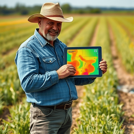
Traditional satellite imagery, such as that from the Landsat or Sentinel missions, offers moderate resolution but suffers from long revisit times—often weeks apart. For a field facing rapid changes in soil moisture, pest pressure, or nutrient status, such delays can render insights obsolete. Constellations like Planet’s Dove, PlanetScope, and the upcoming TerraGen satellites deliver daily or even hourly revisits at 3–5 m resolution. By integrating this stream into a farm’s decision‑making workflow, growers can monitor crop health in near real‑time and respond to stressors before they become costly.
Daily Revisit Cadence Meets Crop Dynamics
- Water Stress Detection: Continuous imaging allows for the calculation of vegetation indices such as NDVI and NDWI each day, revealing moisture deficits that can be mitigated with targeted irrigation.
- Pest and Disease Early Warning: Sudden changes in canopy temperature or reflectance patterns often precede visible symptoms; a daily image cadence can flag infestations early, enabling spot treatment.
- Nutrient Management: Spectral data coupled with machine‑learning models can infer nitrogen status, guiding precise fertilizer applications.
2. Key Technologies Driving Affordability
The affordability of constellation data hinges on several technological breakthroughs:
Miniaturized Sensor Payloads
Smaller, lighter sensors reduce launch costs. Modern LEO satellites weigh as little as 25 kg and carry multi‑spectral cameras with up to 10 bands. Their reduced mass translates directly into lower per‑image pricing for end users.
Edge‑Computing and On‑Board Processing
By performing initial data compression and indexing on the satellite itself, the volume of data transmitted to ground stations drops dramatically. This reduces bandwidth costs and speeds up delivery times.
Cloud‑Based Aggregation Platforms
Platforms like Sentinel Hub, Planet Labs, and emerging ag‑tech SaaS providers offer API access to processed imagery. They layer machine‑learning models that convert raw spectral data into actionable metrics (e.g., yield predictions) without the user needing specialized expertise.
3. Building a Real‑Time Data Pipeline
To fully exploit daily imagery, farms need an end‑to‑end pipeline that ingests, processes, and visualizes data quickly. A typical workflow involves:
- Data Ingestion: APIs pull images as soon as they are available from satellite ground stations.
- Pre‑Processing: Automated orthorectification, atmospheric correction, and cloud masking prepare images for analysis.
- Feature Extraction: Spectral indices, canopy temperature, and texture metrics are computed.
- Decision Support: Models generate recommendations for irrigation, fertilization, or pest control.
- Visualization: GIS dashboards overlay insights on field maps, allowing agronomists to plan field actions.
Integration with on‑farm sensors—soil moisture probes, weather stations, and autonomous tractors—creates a closed feedback loop where satellite data informs ground actions, and ground observations validate satellite estimates.
4. Real‑World Impact: Case Studies
California Almond Orchards
In a pilot program, an almond grower in the Central Valley received daily NDVI and thermal imagery from the PlanetScope constellation. By correlating daily temperature anomalies with yield, the farmer reduced irrigation volumes by 18 % while maintaining consistent nut quality.
Sub-Saharan Maize Production
A consortium of smallholder farms in Kenya adopted a cloud‑based platform that streamed daily images from Planet’s Dove satellites. Early detection of early‑season pest outbreaks allowed for timely pesticide applications, resulting in a 12 % increase in yield and a 7 % reduction in pesticide usage.
Australian Wheat Belt
A large agribusiness leveraged daily imagery to monitor nitrogen deficiency across 10,000 ha. By applying variable-rate fertilizer based on satellite‑derived nitrogen maps, the company saved $200,000 in fertilizer costs and improved overall grain quality.
5. Seamless Integration with Farm Management Systems
Modern Farm Management Software (FMS) like Granular, FarmLogs, and Agro-op are extending their APIs to ingest satellite data. This integration enables:
- Automated field mapping with up‑to‑date land cover layers.
- Dynamic field‑specific recommendations based on real‑time imagery.
- Historical trend analysis that juxtaposes satellite metrics with on‑field observations.
By embedding satellite insights directly into the tools that farmers already use, adoption barriers decrease, and decision makers can act swiftly.
6. Challenges and Risks
Data Quality and Cloud Cover
Even with high revisit frequencies, persistent cloud cover can obscure imagery. Multi‑spectral and radar satellites (e.g., Sentinel‑1) can mitigate this, but integrating radar data adds complexity.
Data Interpretation Expertise
While cloud platforms provide pre‑processed products, translating indices into actionable agronomic advice still requires domain knowledge. Training programs and partnership models are emerging to fill this gap.
Data Security and Ownership
As satellite data streams become integral to operational decisions, ensuring data privacy and secure transmission is paramount. Farmers need clear contracts that outline data ownership and usage rights.
7. The Future Outlook: Beyond 2026
Upcoming constellation projects such as TerraGen and the SpaceX Starlink agronomy partnership promise even higher spatial resolution (≤ 1 m) and higher revisit rates (multiple times per day). Combined with AI‑driven inference engines, the next wave of precision agriculture will feature:
- Autonomous field robots that receive real‑time satellite guidance.
- Dynamic climate‑adaptive irrigation scheduling.
- Fully integrated supply chain dashboards that trace produce from field to table.
Moreover, the proliferation of open‑source satellite data repositories will democratize access, allowing research institutions and smallholder cooperatives to harness the same imagery that large agribusinesses use today.
Conclusion
Satellite constellations have transitioned from niche research tools to mainstream, affordable assets that enable precision agriculture at scale. Daily, low‑cost imagery empowers farmers to monitor crop health, optimize resource inputs, and ultimately increase yields while reducing environmental impact. As technology matures, the seamless integration of satellite data into farm management workflows will become the norm, unlocking new efficiencies across the entire agricultural value chain.